Go To spots
Here is a list and links to various camp spots, awesome 4 wheel drive tracks and general great outdoor areas for all to enjoy.
You can find most of these spots by punching in the GPS co-ordinates or by using google maps on any decent smart phone.
Grant frequently uses a combination of both google earth ( great for planning out & following tracks from above ) and also two fantastic apps which use topographical maps similar to VMS or Hema type mapping however are free, and they are “Memory Maps” and "Gaia" both of which are used on apple devices. "Australian Topographical Maps” which was another good one seems to have vanished and can't get it back for some reason. Both of the aforementioned apps should be available on apple and android devices.
Turon National Park – 33.1982° S, 149.9339° E
Turon is the absolute God’s country !
We love camping here on our annual trips.
It has a beautiful clean river ( that you cross many times depending on where you camp ) that the kids will stay in all day and which can be heard running at night.
Good tracks for day runs and plenty of wildlife to be seen make this an absolute cracker and a real favourite of ours. All within a couple of hours from the heart of Sydney.
_______________________________________________________________________________________________________________________
The Diggins Campground ( within Turon National Park – 33.1838° S, 149.9531° E
The Diggins campground is a great spot central to most of the park and it has drop toilets too which is good if you’ve got little ones that aren’t keen to use those port-a-loos or holes in the ground. From here you can pretty much head out for the day looking at tracks that go right up and along the ridge lines and back down further around in the park. From here you can cross back across the river and follow south towards the Woolshed Flats campground which is up and over the other side of a large hill which can be found by following along Turon River Road.
_______________________________________________________________________________________________________________________
The Woolshed Flats campground 34.0815° S, 146.2214° E
Another campground within the Turon National Park.
There are no drop toilets here so you will have to be toilet “self sufficient” or drive 5 minutes over to the use the loo at The Diggings Campground. It is a pretty cool steep'ish drive too over the ridge top to get from one campground to the other.

_______________________________________________________________________________________________________________________

The Pinnacle Fire trail – -33.213361° S, 149.960077° E – go into Turon National Park, following the track around to the Woolshed Flats campgrounds and then proceed, if game, through the gates and up the Pinnacle Fire Trail.
It leads out to Dark / Sunny Corner
We’ve done this track several times and it would be classed as difficult is spots....but well worth attempt. Pick a good line and you've gained legend status !
_______________________________________________________________________________________________________________________
Newnes Campgrounds and the old ruins – 33.1721° S, 150.2381° E.
This is a great spot to camp, although due to 2WD accessibility it can get a little noisy with overcrowding and younger crowds with loud stereos in the night however it does feature a large number of old ruins from the original Newnes township which was once a thriving shale oil mining industry.
This site is absolutely remarkable when you think there was a whole entire town working and thriving within this valley in the middle of nowhere at the turn of the century. Hats off to the early settlers. You’ll see some remarkably well-preserved remnants of the area’s mining history, including old coke ovens, brick kilns, paraffin sheds and crumbling walls. Very interesting indeed.
_______________________________________________________________________________________________________________________
Capertee River Campgrounds
This is a great little spot with plenty of wildlife around, everything from big goannas to wombats, wallaby’s and kangaroos.
Stunning big open flat grassy areas and a beautiful clean creek running right past the campgrounds, fantastic for cooling off through the day in the heat of summer and then listen to the relaxing sounds of the running creek at night. This is just great !
_______________________________________________________________________________________________________________________
Bungleboori camping area
This spot is a bit of hit and miss. Many reviews say it’s great however as many say a lot of noise at night with music blarring and due to the fact that every man and his dog can get there in 2WD vehicles, often this spot is over populated and left with rubbish everywhere. So camp here at your own discretion. It does make a great spot though as a base camp to head out and hit the tracks taking in the awesome “Lost City” formation and the fantastic Blackfellows Handtrail which features aboriginal hand paintings if you know where to look.
Also too from here it’s not far to the Glowworm Tunnels which is well worth a look.
The Glowworms are an amazing spectacle !
_______________________________________________________________________________________________________________________
Blackfellows Hand Trail and the Baal Bone Gaap 33.3224332, 150.114467
The Blackfellows hand trail is a great little track, especially for those new to 4 wheel driving as it's a good easy drive with a few short rutted inclines and nice sandstone rock work to get you started.
The track winds through the Newnes area all the way from Wolgan Road in in Lidsdale through to the Zig Zag Railway station at Clarence. There is an awesome track off to the left of Wolgan Road Lidsdale almost opposite the equally fun Blackfellows Hand trail. This track can lead you down through the very steep sections of the back of the colliery through Baal Bone Gap but be warned – it’s a bit hairy ! Follow it through if you can and it brings you out through the Gardens Of Stone National Park at Ben Bullen.
Very good track in deed but highly recommended is more than one car and plenty of good quality recovery gear !
_______________________________________________________________________________________________________________________________
Barrington Tops National Park – 32.0671° S, 151.6632° E
Barrington Tops National Park has some of the MOST SPECTACULAR scenery and camp spots IN T H E W O R L D !!! This is god’s country but be warned, make sure you take plenty of warm gear if venturing that way in the colder months as it gets freezing up there – brass monkey cold !!
This truly is an absolutely spectacular area with many tracks to explore and some fantastic campgrounds, both free and paid through NPWS like PolBlue, Devils Hole campground, Black Swamp, Gloucester River campground, Gummi Falls and Horse Swamp campground.
_______________________________________________________________________________________________________________________________

Manning River Camp Grounds –
This quaint little campground area is located within the Barrington Tops National Park and whilst can be accessed by 2WD’s and graded roads, it makes for a great base camp to then venture out from hitting hard tracks all over. Beautiful green grass with absolutely pristine waters, this truly is a great spot.
_______________________________________________________________________________________________________________________________
Camp Cobark - situated 34 km’s west of Gloucester is a beautiful spot for a long weekend getaway. It is very family friendly and offers “bring your swag, tent or van” accommodation along with bunkhouse accommodation. Here you’ll enjoy five kilometres
of peaceful and relaxing river frontage on the beautiful Cobark River. The main campground has toilet’s and shower facilities. The other campgrounds offer bush facilities. The fees here are very reasonable with a main campground featuring a large family/site area and some beautiful riverside camping too. Then there's the Bunkhouse camping. Horse riding is available on site and you are just a stones throw from the beautiful Barrington Ranges National park area too which offers some great four wheel driving, hiking and other activities. Use this as a base camp and go venturing.
_______________________________________________________________________________________________________________________________
Sandon River Campground – 31.18474 S, 152.58181 E
This spot has it all – prime river frontage on one side and protected beach front campsites on the other ! Sandon Point has awesome water front camping with good fishing and great boating opportunities for all. Perfect for families who want to take advantage of fish filled water either by land, kayaks or boat. This is a great family camp spot. family/site area and some beautiful riverside camping too.
Then there's the Bunkhouse camping. Horse riding is available on site and you are just a stones throw from the beautiful Barrington Ranges National park area too which offers some great four wheel driving, hiking and other activities.
Use this as a base camp and go venturing.
________________________________________________________________________________________________________________________________
Watagans National Park – 33.009257,151.36270
The Watagans has some of the best tracks in NSW with everything from mild tracks for stock vehicles through to wild tracks that will rip the guts out of fully fledged monster trucks !
There are literally hundreds of tracks everywhere throughout the
Watagans with plenty of camp sites too, all of which are free too !
Take your mates and recovery gear because you’ll need help on this trip !!!
_______________________________________________________________________________________________________________________________
Yalwal area – 34.9414° S, 150.4142° E
There’s plenty of great camping spots in and around Yalwal and it also boasts some awesome tracks like the famous Monkey Gum firetrail which is sure to test the flex of any vehicle.
Don't forget too, there’s some great spots scattered all around the Danjera Dam so find a cozy spot and set up your gear. There’s some great fishing in the Danjera Dam area too with bass a plenty. Just remember though they are catch and release !
________________________________________________________________________________________________________________________________
Brindabella Ranges – border of NSW / ACT – 35.4167° S, 148.7833° E
This area has truly spectacular camp spots, plenty of water and enough cool crisp air in the evenings to make that swag feel oh so toasty and warm.
It has a similar fee to the Victorian High Country with beautiful big eucalypt's and dense foliage.
With a keen eye too you may just spot some old style mining huts, pretty cool indeed ! Well worth the drive this one.
______________________________________________________________________________________________________________________________
Abercrombie National Park – 34.0968068,149.6903871
Abercrombie National Park has some beautiful places to camp and some great tracks to for exploring.
Steep hills and beautiful creeks are plentiful out here so mark it in your book to get out there and have a look.
Pristine water and grassy knolls await your swag everywhere you turn here.
______________________________________________________________________________________________________________________________
Wheeny Creek Campgrounds - 33.4563088 S 150.7201817 E
This site is a good close to Sydney campground without having to venture too far out. It has some beautiul walking trails and a few good 4x4 tracks, not heaps but certainly enough to keep you entertained through the day. There are toilets close to both campgrounds, with newly installed drop toilets being a recent addition.
Due to the close proximity of the fresh water creek with sand bar and good swimming, it's a fairly popular spot in summer especially. So be prepared to camp in close(ish) proximity to others and whilst it is generally a good spot, it can get a little cramped and a little loud at times.
_______________________________________________________________________________________________________________________________
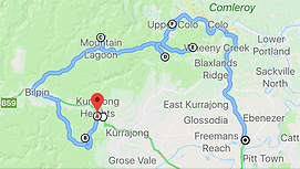
We got up last weekend and went for a drive finding some tracks in and around Wheeny Creek worth driving. It was an awesome day out. I find these day trips such a good stress relief and great when so close to home too. Good easy day out so click this link Burralow to Wheeny Creek which will load the google map as it won't embed like the others on here.

Be sure to take a comfy camp chair and a portable gas BBQ as there's some beautiful spots along the way for a lunch stop.
We entered via Warks Hill Rd going down into Burralow however our plan to exit back out further north near the Bilpin Fruit Bowl was cancelled due to that exit being closed due to excessive rain and fear of damaging the track so we went back out the way we went in and continued up the Bells Line of Rd. Still a great day out either way. This trip is the planned route next time we go again.
_______________________________________________________________________________________________________________________________
More spots are being added all the time and if you’ve found a great spot too, let us know so we can share it with all !
The one biggest reminder I must put out there is PLEASE, PLEASE take all your rubbish with you when you leave any camp spot ! Don't leave any reason for NPWS to close spots because once they're closed, they're gone for good !!!
Remember - leave nothing but tyre tracks PLEASE !!!